Earth Surface and Interior
The Earth Surface and Interior group studies dynamic processes that occur within Earth’s crust, mantle, and core. We develop new methods for using remote sensing data to understand the forces that drive plate tectonics, earthquakes, volcanic activity, landslides, and other solid earth phenomena.
Key science questions our group is focused to addressing include:
- What is the nature of deformation at plate boundaries and what are the implications for earthquake hazards?
- How do tectonics and climate interact to shape the Earth’s surface and create natural hazards?
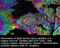
- How do magmatic systems evolve and under what conditions do volcanoes erupt?
- What are the dynamics of the mantle and crust and how does the Earth’s surface respond?
Earth Surface And Interior: Missions and Projects
- ASTER - Advanced Spaceborne Thermal Emission and Reflection Radiometer
- GRACE - Gravity Recovery and Climate Experiment
- NISAR - NASA-ISRO Synthetic Aperture Radar, formerly DESDynI
- EO-1 - Earth Observing – 1
- Landsat - Landsat 8
- AIRS - Atmospheric Infrared Sounder
- MODIS
- VIIRS - Visible Infrared Imaging Radiometer Suite
In addition to the missions listed above, researchers also use GNSS data, airborne data (UAVSAR, MASTER, AVIRIS), and UAVs to constrain models of tectonic, volcanic, and hydrologic processes. The group has expertise in using radar data from other missions, such as Envisat, ALOS, COSMO-Skymed and Sentinel.