Skip Navigation

Projects

SWOT

SWOT Project Logo

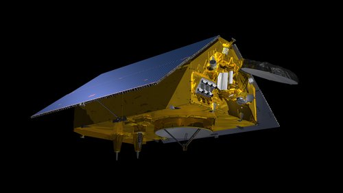
Designed to make the first-ever global survey of Earth's surface water, the Surface Water and Ocean Topography, or SWOT, satellite will collect detailed measurements of how water bodies on Earth change over time. The satellite will survey at least 90 percent of the globe, studying Earth's lakes, rivers, reservoirs and oceans at least twice every 21 days to improve ocean circulation models, and weather and climate predictions, and aid in freshwater management around the world.

People

Photo of Matthew Archer
Matthew Archer
Ocean Circulation And Air Sea Interaction - Technologist
Photo of Arnaud Cerbelaud
Arnaud Cerbelaud
Water & Ecosystems - Postdoctoral Researcher
Photo of Cedric David
Cedric David
Water & Ecosystems - Scientist
Photo of Audrey Delpech
Audrey Delpech
Ocean Circulation And Air Sea Interaction - JPL Postdoctoral Fellow
Photo of Lee-Lueng Fu
Lee-Lueng Fu
Science Division - JPL Fellow, Senior Research Scientist
Photo of Babette Tchonang
Babette Tchonang
Ocean Circulation And Air Sea Interaction - JPL Postdoctoral Fellow
Photo of Manu Tom
Manu Tom
Water & Ecosystems - Postdoctoral Researcher
Photo of Jeffrey Wade
Jeffrey Wade
Water & Ecosystems - Postdoctoral Researcher
Photo of Jinbo Wang
Jinbo Wang
Ocean Circulation And Air Sea Interaction - Technologist