Projects
UAVSAR
UAVSAR, a reconfigurable, polarimetric L-band synthetic aperture radar (SAR), is specifically designed to acquire airborne repeat track SAR data for differential interferometric measurements.
Differential interferometry can provide key deformation measurements, and is important for studies of earthquakes, volcanoes and other dynamically changing phenomena.
Using precision real-time GPS and a sensor controlled flight management system, the system will be able to fly predefined paths with great precision. The expected performance of the flight control system require the flight path to be within a 10 m diameter tube about the desired flight track.
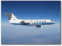
The radar will be designed to be operable on a UAV (Uninhabited Aerial Vehicle), but will initially be demonstrated on a on a NASA Gulfstream III. The radar will be fully polarimetric, with a range bandwidth of 80 MHz (2 m range resolution), and will support a 16 km range swath.
The antenna will be electronically steered along track to assure that the antenna beam can be directed independently, regardless of speed and wind direction.
Other features supported by the antenna include elevation monopulse and pulse-to-pulse re-steering capabilities that will enable some novel modes of operation. The system will nominally operate at 45,000 ft (13800 m).